FOR YOUR CONSIDERATION:
the Great Divide Basin crater
by
Randy Gene Johnson
977 Dayshia Lane
Cheyenne, Wyoming 82007-9168
Copyright
© Randy Gene Johnson 2013
All Rights
Reserved
ABSTRACT
This research paper is based upon
findings from Google Earth, Google Maps and from personal observations. Within
this document, I will show evidence that at one time, Colorado, Utah and
Wyoming were struck by a meteorite and that it created a large crater nearly
200 miles in diameter. My research will show several signs of a fierce impact
within the boundaries of the crater.
Using Google Earth and Google Maps,
We will see that the crater is highly visible from space and down to a view of
just the area in question. The latter view will demonstrate the destruction
that the area has experienced.
With the assistance of Google Earth, elevation profiles will
be made to indicate the debris field and confirm that the meteor impact was
from the West North West and it left debris to the East South East. These
elevation profiles will show that debris was left in several states. I will
show proof that the debris can actually be viewed today.
I will also show that this impact may be dated
by fossil record. Beyond fossils, this meteorite also gave Wyoming much of its
natural resources.
This Research Paper is dedicated to my family
Pamela A.
Johnson, my wife, who stands beside me through rough times;
Doris L. Johnson, my mother, who never doubted my
interests;
Merle F. Johnson, my father, who taught
me to think out of the box;
E. W. “Jim” Beckman, my grandfather, who
showed me to always look on the other side of the rock.
1.
INTRODUCTION
My name is Randy Johnson. I am not a
geologist but I have always been fascinated with geology. Having grown up in
Wyoming, I have wondered at the beautiful and vast intensity of the exposed
geological features this state has. Often I really wonder just how certain
features in Wyoming came about. There are a few areas that stand out as showing
some major geological changes that show a violent past. An abrupt up thrust in
the sedimentary rocks exposed along Interstate 80 just east of Rock Springs is
just the start of my query.
Figure
1, Ridge Just East Of Rock Springs
2. THE QUERY CONTINUES
Other areas of Wyoming show more
clues to a violent past in the state.
2.1 Muddy Gap Area
The angle of the sedimentary rocks coming out of the ground
just south of Muddy Gap has always caught my attention.
Figure
2, Sedimentary Rocks At An Angle
What force could cause these rocks break away from the Earth
and shove them out of the ground like this? I have always questioned how these
rocks ended up resting at such an angle. Could there be some fault here that
has twisted them? Could a fault be so short to only affect this local area?
Every time that I drove past these rocks my mind went through several scenarios
of what could cause this up lifting.
Figure
3, Major Uplift Near Muddy Gap
2.2 Ferris Mountains
Very close to this uplift are the Ferris
Mountain’s. They can be seen in the background of Figure 3. This short range
also shows signs of a violent past. Along the side of the range is a large
outcrop of limestone “fins”. These fins are known as the Madison Formation and
extend nearly the entire length of the Ferris Range.
Figure
4, Ferris Mountains Madison Formation
Just what type of force was used to push all this limestone
up and out of this mountain? This must
have been something very powerful!
Figure
5, Ferris Mountain Range
3. COLORADO AND UTAH SHOWS SOME
DISTURBANCES AS WELL
Although being southeast of the
visible crater, A National Monument in Colorado and Utah reveals more clues to
a violent past. A very major occurrence is now visible at Dinosaur National
Monument.
Figure
6, Mitten Park Fault
3.1 Mitten Park Fault
Located
along the Green River, the Mitten Park Fault shows a major force that actually
buckles the sedimentary layers into a vertical attitude. Being surrounded by
fairly level sedimentary makes these features cry out “What could cause this”.
Figure
7, Split Mountain
3.2 Split Mountain
Only 15 miles southeast, once again
among normal flat sedimentary appears another great sloping section of heavily
tilted sedimentary layers. As Split Mountain repeats the same pattern viewed
near Muddy Gap in Wyoming.
Figure
8, Split Mountain Panorama
Split
Mountain dives down into the earth creating a very spectacular view.
Figure
9, Split Mountain Ends
3.2 Fortification Rocks
Another vertical anomaly can be
found 77 miles east-northeast of Dinosaur National Monument. This formation is
easily dismissed due to its size but it falls right into location near the rim
of the crater. This range of rocks is nearly 2 miles long and has been
contributed to volcanic action. Located along Highway 13 between Craig,
Colorado and Baggs, Wyoming, sits an outcrop of vertical rocks known as
Fortification Rocks.
Figure
10 Fortification Rocks
Hardly noticeable but this range
sits West to East and fits into the rim area of the crater. It’s a single
anomaly but when added with all the other evidence found in the rim areas, they
all tie together to point out an area of massive disturbance.
Figure
11, Fortification Rocks Side View
Once
again we have seen the evidence of the disturbance but what makes it
identifiable as a crater? The next step is if it can really be viewed as a
crater.
4. INTRODUCING, THE GREAT DIVIDE BASIN
CRATER
It
takes a little looking but it is there. Visible from even such a distant view
of the Earth as provided from Google Earth, there is a lighter colored round spot
visible in Colorado, Utah and Wyoming. If you look to the right of the Great
Salt Lake, it’s there.
Figure
12, View Using Google Earth
4.1 Viewed from Space.
This
is an untouched screen shot from using Google Earth. Did you spot it? Just to
confirm the location, Figure 13, has an arrow pointing to it.
Figure
13, Same View With Arrow Pointing To Round Spot
Does that somewhat round spot that is much lighter in
color than its surroundings make you wonder? Once you notice the spot, it
starts to be very noticeable whenever this location is viewed. Even Bing Maps
indicate the spot with a world view.
Figure
14, Spot View Using Bing Maps
Even with no state outlines, the spot is quite visible if
you look for it.
Figure
15, Same View With Arrow Pointing To Spot
These Bing Maps images actually enhance the eastern rim
of the crater.
Figure
16, A Closer View From Google Earth Clearly Showing The Round Spot
4.2 A Closer Look.
Using Google Earth, this is a closer view with the states
outlined. The closer the view starts to
really point out the spot. This view also asks quite a few questions. One
question I’ve always wondered is why the Wind River Range in Fremont County,
Wyoming, was cut off from the Rockies in Colorado by the Red Desert in southern
Wyoming?
Figure
17, Same View From Google Earth With The Spot Circled
4.3 Using Google Maps.
Using Google Maps, the much closer view in Figures 18 and
19 really starts to show the size of the spot. With a diameter of over 200
miles, the spot really starts to look more like a crater.
Figure
18, View Using Google Maps Clearly Showing The Lighter Colored Spot
Figure
19 Same View From Google Maps With The Spot Circled
Figure
20, The Great Divide Basin Crater
4.4 Portrait Of The Great Divide Basin Crater.
The view in figure 20, using Google Maps completely
defines the Great Divide Basin Crater and shows the destruction of the impact.
The discoloration of the majority of the area is very distinctive. The area
just southeast of South Pass, Wyoming shows the dark hue of the red soil and
then it turns to a soft pastel and even the greenery turns pale.
4.5 Putting All Of The Pieces Together.
Using Google Earth to view the figure locations around
the Great Divide Basin Crater indicates a somewhat circular pattern. From the
angled sedimentary rocks near Muddy Gap, and the limestone fins on the Ferris
Mountain Range to the North, swing to the southwest and see the ridge in the
sedimentary rocks near Rock Springs. South of the ridge, much is shown in
Dinosaur National Monument with its Mitten Park Fault and Split Mountain.
Working east finds Fortification Rocks north of Craig, Colorado.
Figure
21, Figure Locations
5.
WHERE IS THE CRATER RIM
We have all
viewed the typical rim of a crater, but why isn’t there a crater around the
Great Divide Basin crater? Most craters are from a meteorite strike coming into
the Earth at close to 90 degrees or nearly vertical. My investigation has found
that this meteorite actually came at a much lesser angle. From the debris
field, this impact was from something striking the Earth coming in north of the
Great Salt Lake and crashed traveling east southeast. Below is an untouched
screen shot from using Google Maps showing the crater and to the east, the
debris field.
Figure
22, View Of Crater And Debris Field
When
I initially looked into where the debris could be found, I focused on eastern
Wyoming, northern Colorado and the western region of Nebraska between the North
and South Platte rivers. I looked at the elevation profiles along the
Wyoming/Nebraska border and found the plateau I was expecting.
Figure
23, Elevation Profile North To South
I
then decided as more proof to do a much longer profile to show this thought was
correct and show the flatter regions beyond the expected debris field. An
Elevation Profile was made once again along the Wyoming/Nebraska state border
going from just south of the Black Hills of South Dakota to the southern border
of Colorado. Instead of confirming my idea of the location of the debris field,
this profile opened my eyes to the true extent of the debris field.
5.1 Much Larger Than Expected
The longer profile revealed the
crater rim and indicated a much enlarged area than I had expected. The previous
view from the North Platte River to the South Platte River was only about a
third of what I was searching for. The actual location from this profile showed
the field originating near the Nebraska Border with South Dakota and lead south
to central Colorado. My simple idea of a small debris field has now grown to
quite large proportions. This confirmed I would need to go to much further
lengths to find the true boundary of how far the ground had been displaced from
this impact.
Figure
24, Longer Elevation Profile North To South
Figure
25, Much Longer Elevation Profile North To South
Again
I lengthened the elevation profile to now come from the border from North
Dakota and South Dakota down to the southern border of New Mexico. This profile
was long enough to make confirmation of the rim boundaries of the debris pile.
The Northern Rim lies almost due east of the top of the crater and the Southern
Rim matches with being a bit farther south. This view widened the area of
debris thrown out from the impact to now include a majority of the state of
Nebraska and large portions of Colorado and Kansas.
5.2 Multiple Elevation Profiles
Since the much longer profile
indicated better detail, I then made six other elevation profiles to compare
with the original that followed the eastern Wyoming border.
Figure 26, Locations Of The Seven
Elevation Profiles
These
elevation profiles are numbered Profile 1 to Profile 6 and run from the west to
the east.
Figure 27, Elevation Profile Number
1
Figure 28, Elevation Profile Number
2
Figure 29, Elevation Profile Number
3
Figure 30, Elevation Profile Number
4
Figure 31, Elevation Profile Number 5
Figure 32, Elevation Profile Number 6
6. WHAT MAKES THIS THE DEBRIS FIELD
Since this
impact occurred several million years ago, proof that the debris is hard to
find. There is an area in Wyoming that
has mystified a lot of people, but when it’s realized how these strange
formations were formed, it is very obvious that this is debris from a very
serious impact. Let us look into why these boulders are just sitting up there
as if they have been placed there.
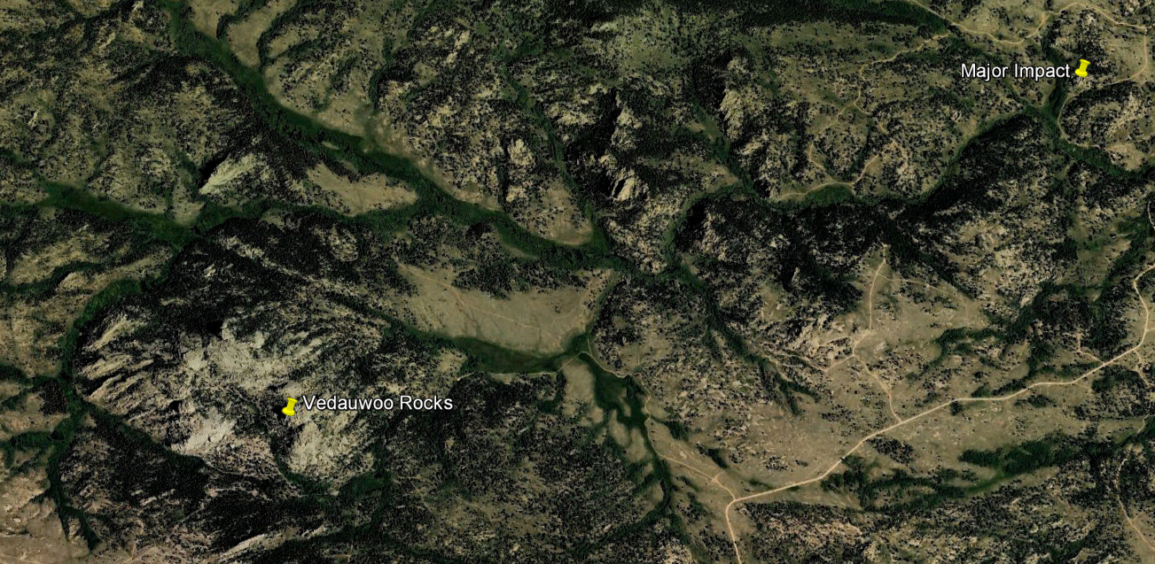
Figure 33, Vedauwoo Rocks, Wyoming
6.1
Vedauwoo Rocks
Known for being one of
the greatest rock climbing locations in the world, Vedauwoo is located 30 miles
west of Cheyenne, Wyoming, just off Interstate 80.
Figure 34, Vedauwoo Map
Any internet search of Vedauwoo will
show some wondrous pictures and the endless question of what happened to form
this area. With the idea of a possible meteorite impact west of this area, I
think of it as just the beginning and confirmation of a giant debris field. The
next two figures 35 and 36 will bring focus to the Vedauwoo area. Figures 37 to
41 shows the area and focuses upon the large boulder placements found
throughout the area. Looking onto the
large mass of rocks, I even wonder if the large stadium sized, were originally
somewhere west of their current location.
Figure 35, Vedauwoo Exit
Figure 36, Vedauwoo Rocks Arial View
Figure 36
is a close up of Turtle Rock, the main rock structure at Vedauwoo.
Figure 37, Vedauwoo Rocks, Wyoming
Figure 38, Vedauwoo Rocks, Wyoming
Figure 39, Vedauwoo Rocks, Wyoming
Figure 40, Vedauwoo Rocks, Wyoming
Figure 41, Vedauwoo Rocks, Wyoming
Figure 42, Climbing Vedauwoo Rocks
As visible
in figure 42, we can see that these are some very large rocks and have mostly
vertical and wide cracks that make them such a climber’s paradise. A longer study brings up questions of the
cause of the cracks. Just to the left of
the climbers shows cracks that appear to be caused from some type of impact
slivering the bottom left corner of this rock. Doesn't it look as if was
dropped and also caused the crack the climbers are using? Next, we will look at
another rock that really gives us an impact.
Figure 43, Major Impact Location
6.2 Major
Impact
Just northwest of Turtle
Rock is a rock many climbers call Amazing. It gathers that name from its
elaborate maze and hallways that are inside this rock structure. The overhead
view using Bing Maps in figure 44 shows how fragile this rock structure was.
Figure 44, Major Impact Overhead
What force
could have shattered this giant boulder? This is far beyond water getting into
cracks and freezing. From this view, it
looks as if this boulder was sliced up. I can see no way to explain this
formation other than it was dropped here at a very high velocity. Is this
debris from someplace more in central Wyoming or is it a piece of what caused
the crater? It would be quite interesting
to see what is under this formation and to see if this was even an original
part of Wyoming.
Figure 45, Major Impact
Here is a
ground level picture taken of the Amazing Rock. I feel this is the one picture
that puts all of this together. This formation is clearly an impact that
shattered and spread many components around the base.
Once again, I am not a geologist,
but I have put together some very strong evidence that Colorado, Utah and
Wyoming has had impact with a foreign body from space. Now to look at just how
far east does this impact field extend to?
7.
THE EASTERN END OF THE DEBRIS FIELD
We have viewed the profiles and
witnessed the impact but can there actually be a way to find the eastern end of
the debris field? Actually many researchers have found it and it has museums
and a television show to prove it.
7.1 Brenham, Kansas
Figure 46, Brenham, Kansas
Located between Greensburg and
Haviland along US 54 Expressway is the community known as Brenham, Kansas. The Brenham meteorites fell in prehistoric times.
They were recognized by Native Americans as something quite extraordinary;
pieces having been found in the Hopewell Culture burial mounds in the Little
Miami Valley, Ohio nearly 1000 miles away.
One of the most significant meteorite finds in 1882 near the town of Brenham,
in Kiowa County Kansas, known as the Brenham meteorite, was discovered by a
farmer's wife, Eliza Kimberly. It was the tireless efforts of this pioneer woman,
which led to them being confirmed by scientists to be meteorites in the late
1800s. She collected many samples and subsequently convinced Professor F. W.
Cragin, of Washburn College, Topeka, Kansas, to come, examine them and purchase
a few. Later, Clyde Fisher, of the American Museum of Natural History, came to
examine them and to excavate more pieces. In the 1920's and 1930's, Harvey
Nininger, famed meteorite hunter, unearthed many more from the same area. In
1949, H. O. Stockwell discovered a 1,000-pound specimen that is temporarily on
display in the City Building on Main Street in Greensburg, Kansas. In the fall
of 2005, a specially designed metal detector located the largest piece yet from
the Brenham site, a 1,400-pound meteorite. This latest large specimen is an
oriented pallasite, a stony-iron body that remained oriented in one position as
it fell, rather than tumbling, thus creating a rounded or conical shape on the
side that took the brunt of the heat upon entering the atmosphere. Only two
larger ones of that type are known to have been found in the world. All of the
Brenham specimens are believed to have come from one meteorite that broke up
during its fall. Scientists previously estimated that this fall occurred about
20,000 years ago, but recent evidence suggests it fell around 10,000 years ago.
Over three tons of Brenham material has been found.
The Kansas
Meteorite Museum, 21255 Street K, Haviland, Kansas 67059 has many of these
meteorites on display.

Figure 47, Brenham
Meteorite fragments in the Kansas Meteorite Museum
7.2
Steve Arnold and Geoffrey Notkin , Meteorite
Men in Brenham, Kansas
Anyone that has watched Meteorite Men on the Science Channel have been
viewing the discovery and extraction of the meteorite remains that created the Great
Divide Basin Crater. Their website, http://www.meteoritemen.com/
profiles a lot of their work around Brenham.
Figure 48, Steve Arnold and Geoffrey Notkin
Steve Arnold, in October of 2005 made one of the greatest meteorite discoveries of modern times. In
a field in rural Kansas, Steve found a complete, oriented pallasite, weighing
almost three quarters of a ton. Excavated from its resting place
seven-and-a-half feet underground, it is the largest pallasite ever recovered
in the United States, and the largest oriented pallasite in history.
8.
OTHER CLUES TO AN IMPACT
Wyoming and
states surrounding it have some interesting features. In the early 1970’s I
would go with my grandpa Beckman to Farson, Wyoming and do some fishing. We
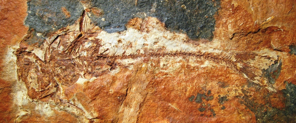
didn’t use hooks, lines or poles. Our fishing was done with shovels. There are
a couple areas in Wyoming that have Fossil Fish Beds. It was very surprising to
dig down thru levels of shale and find a layer that had a fish fossil and a
couple layers underneath to find several more fish. Although it is now illegal to
do this type of fishing, I always wondered what happened to leave us with such
a fossil record.
Figure 49, Fossil Catfish
Figure 50, Fossil Fish In Mass
8.1 Fossil Record
Located
west and southwest of the crater are the Farson Fish beds and the Kemmerer fish
beds which lay in the Green River Basin. These are the two main sites for
finding fossils but they are not the only places. As expected, Colorado and
Utah have their sites as well.
Figure 51, Fossil Fish Locations
These
fossil beds include much more than a few fish. Birds, insects and plants can be
found in the same locations. All of these fossils show that Wyoming was more of
a tropical region when these were formed. I always wondered how all these
fossils would form. Was this a large lake that dried out trapping the fish? Why
are these fish located through several levels? Couldn't these levels be the
splatters from a large lake that may have been struck from something beyond
this Earth? Scientists dated the material in the Green River Locality using strati graphic methods of dating. They concluded that the transition occurred
between 49.7 and 50.7 million years ago and lasted less than half a million
years. By dating the rock fossils to the Green River Formation in the Eocene
Era gives as an approximate time of the impact.
Figure 52, Coal Trains In Wyoming
8.2 Fossil Fuel
Wyoming is
very abundant with coal, oil and natural gas.
Figure 53, Natural Gas Drilling near
Pinedale, Wyoming
Figure 54, Wyoming Coal Bearing
Areas
Could this
abundance be attributed to a meteorite strike? Although appearing coincidental,
a meteorite strike may have caused massive wildfires charring the wood then
burying it underneath a large amount of dirt in a very short time. Today we are
mining and drilling energy from the results of a very tragic disaster.
9.
CONCLUSION
The journey
has led from space to fossils found underground. I have shown the “spot” that
can be seen on Google Earth, Google Maps and even on Bing Maps. The area around
the crater has shown several signs of powerful force deflecting sedimentary
rocks into sharp and high angles.
Utilizing
the elevation profile found on Google Earth, I have indicated a very large
debris field covering multiple states.
The debris is still visible in the form of rock structures found around
Vedauwoo, Wyoming and this may include pieces of whatever stuck the Earth to
cause this destruction.
Finally I
explored into the depths of underground fossils and fossil fuels that may have
been caused from this impact. Like I have said before, Wyoming shows a quite
violent past and hopefully this paper will lead to research to confirm the
Great Divide Basin Crater.
Appendix 1, Meteor
Craters from Geology.com
Figure
55, Screen Print From Geology.com
From
a website mapping locations of visual craters, two such locations are noted to
the southwest of the visible location of the Great Divide Basin Crater.